St. John can be hit by a hurricane from June to November, most often from mid-August to mid-October. In a typical year, though, none comes close. If one does threaten, the real risks for a visitor are stopped ferries, cancelled flights and several days without power or water, more than injury. Buy travel insurance when you book, before any storm has a name, and follow the National Hurricane Center from about a week before you fly. Earthquakes are frequent but small; a tsunami is rare, but if you feel a strong or long quake on the beach, walk uphill right away without waiting for a siren.
Official notice — National Weather Service San Juan and VITEMA
Watches, warnings and evacuation orders for St. John come from the National Weather Service in San Juan, the National Hurricane Center and the Virgin Islands Territorial Emergency Management Agency (VITEMA). When one is in effect, follow it. Their instructions outrank anything on this site.
At a glance
- Hurricane season
- June 1 to November 30, peak around September 10
- NOAA National Hurricane Center · verified
- 2026 season
- No watch or warning for the U.S. Virgin Islands (as of Nov 18)
- NOAA National Hurricane Center · verified
- Last storm to hit
- Tropical Storm Ernesto made landfall on St. John on Aug 13, 2024
- NOAA National Hurricane Center · verified
- Insurance
- Buy before a storm is named; after that it is not covered
- Squaremouth (travel insurance comparison site) · verified
- Tsunami safe height
- 82 ft above sea level, or inland
- Virgin Islands Territorial Emergency Management Agency (VITEMA) · verified
- Alerts
- Phone alerts arrive without sign-up; add Alert VI at vitema.vi.gov
- National Weather Service · verified
Live conditions are on /now/alerts (official alerts).
Live conditions are on /now/tropical (tropical outlook).
Live conditions are on /now/alerts (tsunami status).
Live conditions are on /now/earthquakes (recent earthquakes).
Live conditions are on /now/power (power status).
Live conditions are on /now/ferries (next ferries).
Hurricane season
The Atlantic season runs June 1 to November 30. It peaks around September 10, with most activity between mid-August and mid-October. In an average year the whole Atlantic sees 14 named storms, 7 hurricanes and 3 major hurricanes, and most of them never come near the Virgin Islands. We found no reliable figure for how often a hurricane passes close to St. John.
Every season is different. 2026 has been quiet: NOAA expected a below-normal year and in August lowered its forecast to 7 to 13 named storms because of a strong El Niño. By November 18 the Atlantic had had 10 named storms and one hurricane, and none put a watch or warning on the U.S. Virgin Islands. Tropical Storm Dolly was forecast to bring rain in late August but fell apart far to the east. On November 18 the National Hurricane Center’s outlook showed nothing near the islands. The season ends November 30; see the tropical outlook for the current state.
Whether a fall trip is worth it (lower prices and quiet beaches against storm risk, the wettest weeks and closed restaurants) is covered in the best time to visit.
Storm history
These are the storms that shaped St. John in living memory, from the official reports.
| Year | Storm | What happened on St. John |
|---|---|---|
| 1989 | Hurricane Hugo | Winds of 140 mph across the territory; 3 deaths and 20,000 people homeless in the U.S. Virgin Islands |
| 1995 | Hurricane Marilyn | About 80 percent of buildings on St. Thomas were damaged or destroyed; the storm tide on St. John reached 11.3 ft above mean sea level |
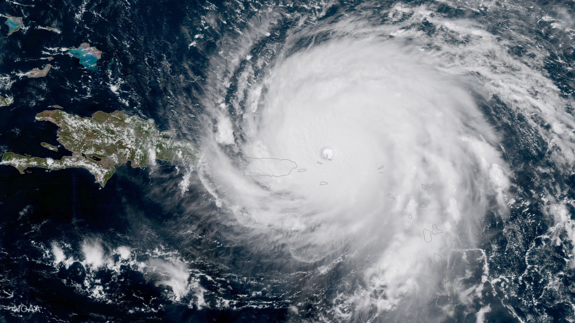
| 2017 | Hurricanes Irma, Maria | Irma, a Category 5, passed just north on September 6; the islands were stripped of most of their foliage. Two weeks later Maria’s rain brought floods and mudslides |
| 2024 | Tropical Storm Ernesto | Landfall on St. John on August 13 at 65 mph; 5 to 9 inches of rain, and more than 45,000 customers in the territory lost power |
| 2025 | Hurricane Erin | At Category 5 strength it passed north-east of the British Virgin Islands on August 16; its outer bands swept the islands without a watch or warning |
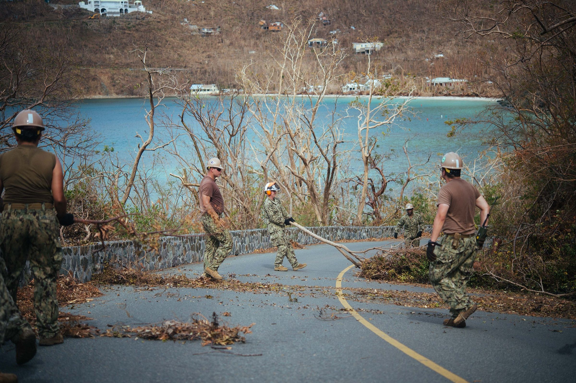
Irma and Maria are the benchmark: on St. Thomas and St. John the hurricane center reported widespread catastrophic damage, collapsed fire and police stations and badly damaged hospitals, and Navy and National Guard crews were brought in to clear the roads. Ernesto shows that a tropical storm, not only a major hurricane, can cut the power for the whole island for a while.
If a storm threatens
Storms rarely arrive without warning. The National Hurricane Center’s outlook shows a disturbance days ahead, and a watch means tropical-storm or hurricane conditions are possible within 48 hours, a warning that they are expected within 36 hours. The forecast cone shows where the center of the storm will probably go, not how big it is: wind, rain and surf reach far outside it, as Erin showed.
What changes for you, in the order it usually happens:
- Ferries stop first. Before Tropical Storm Tammy in October 2023, the Port Authority suspended the Cruz Bay–Red Hook ferries in the evening and the Coast Guard closed all seaports at 8 PM. If your flight leaves from St. Thomas, cross early; the car barge stops too. See ferries.
- Ports close in stages. The Coast Guard sets port conditions from 48 hours before gale-force winds; at the last stage, ports close to all commercial traffic. During Fiona in 2022 they reopened three days later.
- Flights are cancelled as the storm nears. Airlines often publish a travel waiver for the islands that lets you change for free; check yours and rebook early, because seats on the last flights out go fast.
- Shops sell out. Fill the car with gas, get cash and buy water, food and batteries for several days.
VITEMA tells St. John residents to be ready for at least 10 days on their own after a major storm, because the ferries may take longer to restart. Public shelters on St. John are the Adrian Senior Center and the Cruz Bay Community Hub; your villa manager or hotel is the first contact for guests.
Tip
If a named storm is forecast near the islands in the next five days and you have not arrived yet, ask your airline and villa about changing dates before a warning is issued. Once you are on the island, staying put in sturdy lodging above the shore is usually safer than a last-minute crossing.
Travel insurance
For August to October trips, or for an expensive villa you cannot cancel, travel insurance is close to essential. Villa contracts on St. John are strict: one large agency books non-refundable stays and, if a storm forces a cancellation, holds the money for a future stay instead of refunding it. Serious medical cases also have to leave the island (see the health center).
Buy it when you pay the deposit. A storm counts as a known event once it has a name. Insurers say you must buy before the storm is named or forecast, typically at least 24 hours before; the territory gives the same warning for home insurance.
Read what triggers the cover. A named storm alone usually does not let you cancel. Typical policies pay when a hurricane warning or a mandatory evacuation is issued for your destination, when the airline stops flying, or when your lodging becomes uninhabitable. Deciding not to go because the forecast looks bad is covered only by a “cancel for any reason” upgrade, which costs more, pays back only part of the trip and must usually be bought within two or three weeks of the deposit.
Questions to ask before you buy:
- Does it cover a storm that is named after I buy?
- Does a hurricane warning for St. John let me cancel or come home early?
- Does it pay for medical evacuation, and to where?
- Does my US health insurance already cover care in the Virgin Islands?
This is general information, not advice on a particular policy; the policy wording decides. stj.fyi does not recommend or sell insurance.
Earthquakes and tsunamis
The Virgin Islands sit near the edge of the Caribbean plate, and small earthquakes are routine. The U.S. Geological Survey recorded 458 quakes of magnitude 2.5 or more within 62 miles of St. John in 2026 by mid-November, the largest a 4.9 out at sea; almost nobody felt most of them. The larger 2020 sequence off Puerto Rico, with a magnitude 6.4 on January 7, did its damage there, about 150 miles away.
The benchmark for St. John is November 18, 1867. A magnitude 7.5 earthquake in the Anegada Passage, east of the island, was followed by a tsunami about 20 ft high at Charlotte Amalie and up to 30 ft on St. Croix; witnesses saw the sea pull back on St. John. Nothing like it has happened since. The most recent alert was on June 24, 2026, when two large earthquakes off Venezuela led to a tsunami advisory for Puerto Rico and the Virgin Islands that was cancelled the same evening.
What to do. A tsunami from a nearby quake could arrive within minutes, before any official message.
- The warning signs are natural: shaking that is strong or lasts long, the sea suddenly draining away like a very low tide or rising fast, or a loud roar from the ocean.
- Go at once. Walk off the beach to high ground, at least 82 ft above sea level, or inland. On most St. John beaches the hills start right behind the sand.
- Stay there. “The first wave may not be the last or the largest”; go back only when officials say it is safe.
- On a boat, follow the captain and the Coast Guard; open deep water is usually safer than a harbor.
VITEMA publishes a St. John tsunami evacuation map with the hazard zone, routes and assembly areas, and St. John is a TsunamiReady community. The island has seven tsunami sirens, tested on the third Thursday of each month at 11:15 AM. Outside that time, VITEMA says to treat a siren as a real emergency. A silent siren is not an all-clear: sirens can fail, and natural warning signs come first.
Official notice — National Weather Service
“Do not wait for an official tsunami warning or for instructions from local officials.” If you feel a strong earthquake or see the ocean behave strangely near the coast, move to high ground or inland right away and stay out of the hazard zone until officials say it is safe.
The official messages use four levels: a warning means a tsunami that may cause widespread flooding is expected or occurring (go to high ground); an advisory means strong currents and dangerous waves near the water (get out of the water and off the beach); a watch means a distant quake may have caused a tsunami (stay alert); an information statement means there is no threat or it is not yet known.
Tip
When you arrive at a beach, look for the nearest path or road uphill. On a villa booking, ask the elevation; most hillside villas are well above 82 ft.
Official alerts
You do not need an app to get the most serious warnings. Wireless Emergency Alerts reach phones in the area automatically, with no sign-up, as long as the phone has signal and alerts are turned on in its settings. For more, use these official channels:
| Who | What it covers | Where |
|---|---|---|
| VITEMA (Alert VI) | Territory emergencies, evacuations, shelters; texts and emails to subscribers | vitema.vi.gov (“Get alerts”); Facebook /vitema, X @readyusvi |
| National Weather Service San Juan | All watches, warnings and advisories for St. John: storm, flood, heat, surf, tsunami | weather.gov/sju |
| National Hurricane Center | Tropical outlook, storm advisories, the forecast cone | nhc.noaa.gov |
| Tsunami warning centers | Tsunami messages for Puerto Rico and the Virgin Islands | tsunami.gov |
| Puerto Rico Seismic Network and USGS | Earthquake reports for the Virgin Islands | redsismica.uprm.edu, earthquake.usgs.gov |
| Virgin Islands Port Authority | Ferry, port and airport notices | viport.com |
| Virgin Islands National Park | Park closures, trails and beaches | nps.gov/viis |
Sign up for Alert VI before you travel; when it launched in 2018, people planning a trip to the islands were invited to sign up too. St. John is in the National Weather Service’s zone VIZ001, “St. Thomas, St. John and adjacent islands”, and the marine zones AMZ716 (the Atlantic waters to the north) and AMZ726 (the waters around St. John); you will see those names in the alerts. Tsunami messages for the islands come from the Pacific Tsunami Warning Center, which took over the job in 2017.
Two limits to know. Cell towers and power can fail in a storm, as the power did across the island during Ernesto, so a battery or hand-crank radio is the fallback. And an empty list never means safe: a feed that stops is not an all-clear.
stj.fyi gathers these sources on alerts, with each source’s time and a clear “unavailable” note when a feed fails, and publishes the alerts as an RSS feed at /alerts.xml. It is a convenience, not a warning service: VITEMA and the National Weather Service come first.
After a storm
After a direct hit, expect the island to run slowly for days or weeks. Roads may be blocked by fallen trees and power lines, power and water can be off, and cell service patchy. Stay off the roads until crews have cleared them and stay away from downed lines.
- Getting off the island. Ferries restart only after the Coast Guard reopens the ports and the docks are checked. Watch the Port Authority’s notices and your airline; the next ferries page shows what is running.
- Power and water. The power status page links the utility’s outage map. Keep the drinking water you bought until the utility says tap water is safe again.
- The national park. Trails and beaches reopen as rangers clear them, and some stay closed for a long time after a big storm. Check the park’s alerts before you go.
- Medical help. The Myrah Keating Smith health center in the middle of the island is the 24-hour emergency clinic; serious cases go to St. Thomas.
Tip
Keep screenshots of the hurricane advisories, the ferry and airline cancellations and your host’s messages. Insurers ask for them, and they are hard to find again once the storm has passed.
If you booked a trip for after a storm, ask your host directly how the property and its road came through. Island businesses reopen at different speeds, and local news and the businesses’ own pages are more current than any list.